
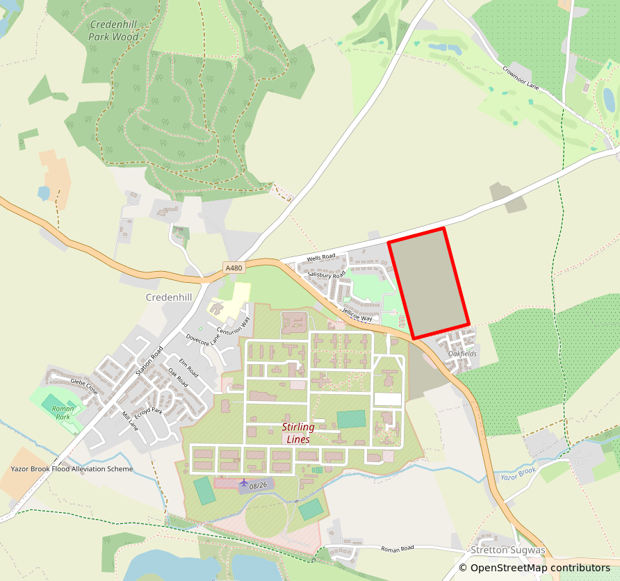
The owner of the field north of Oakfield View in Credenhill (“land north of Granary Cottages”) has submitted a planning application for a development of up to 250 new houses on the land:
Background: informal consultation
On 16th April 2026, Credenhill Parish Council shared an indicative satellite plan (PDF) and an ‘Executive Summary’ from the developer’s agent (PDF), along with an informal survey for residents to submit their views to the Parish Council before a council meeting on 20th April.
The agent’s executive summary read:
- Herefordshire Council cannot demonstrate a 5 year supply of housing land (a key measure) meaning that the presumption in favour of sustainable development applies.
- Herefordshire Council have confirmed through formal Pre-Application Advice that this is a sustainable location for new housing.
- The emerging Local Plan 2025-2045 will require Credenhill to deliver around 300 new houses.
- Credenhill does not have a Neighbourhood Development Plan, nor is there one in preparation.
- There are no allocated housing sites in or around Credenhill.
- The outline planning permission for 100 houses on the land to the south of the A480 has lapsed, and the site has been acquired by the MOD as part of the expansion of the Credenhill Garrison.
- Technical Reports have been commissioned and satisfactorily completed with regard to:-
Highway Access and Travel Plan
Foul & Surface Water Drainage
Landscape Impact
Acoustics
Ecology
Biodiversity Net Gain.
(Note that the “5 year supply of housing land” reference there is to a provision in the December 2025 National Planning Policy Framework, which the government replaced in August 2026 with a version that no longer includes this test.)
What’s in the application
P262019/O is an “Outline application with all matters reserved, save access”. This means that Herefordshire Council needs to decide only two things:
- “Outline” – whether a new housing development of this general size in this location is acceptable in principle.
- “Access” – whether the applicant’s plans for road access to the site are safe and suitable for the local area.
Herefordshire Council’s webpage for the application includes links to all of the applicant’s supporting documentation, namely:
- Application Form (PDF) – outlines exactly what the applicant is applying for.
- Design & Access Statement (PDF) – the overarching “story” of the scheme: it explains the design rationale and the access strategy, pulls together all the specialist evidence, and argues the case against planning policy.
- Landscape & Visual Impact Assessment (PDF) – a specialist study of how the development would change the landscape character and the views people have of the site, with proposed planting to soften those effects.
- Transport Assessment (PDF) – demonstrates that the surrounding road network can safely absorb the traffic 250 homes would generate, modelling the trip numbers (around 134 vehicle trips in the morning peak, 128 in the evening) and the A480 junction.
- Residential Travel Plan (PDF) – a package of measures (and follow-up monitoring surveys) to encourage residents to walk, cycle and use buses and reduce car trips.
- Noise Assessment (PDF) – models whether future residents would have acceptable indoor and garden noise levels, concluding the site is low-risk, with only minor glazing/ventilation mitigation needed for the homes closest to the A480.
- Flood Risk Assessment & Drainage Strategy – assesses the site’s flood risk and sets out how rainwater and foul drainage would be handled in general, with detailed design left to a later stage.
- A Tree Survey (PDF), Tree Schedule (PDF), and BS5837:2012 Arboricultural Survey & Outline Impact Assessment (PDF) – recording every tree and hedgerow on the site, and assessing how they’d be affected by the development.
- Preliminary Ecological Appraisal with Preliminary Roost Assessment (PDF) – a baseline wildlife survey, including a preliminary assessment of bat-roosting potential.
- A Biodiversity Net Gain Assessment (PDF), and BNG modelling spreadsheet (XLS) – demonstrating that the development would increase biodiversity on the site by at least the mandatory 10% minimum.
The application webpage also includes a number maps/plans. Note that the main Site Plan (PDF) and the Proposed Site Access Plan (PDF) are binding, but, as explained below, the Indicative Site Layout (PDF) and Landscape Masterplan (JPG) are just two examples of how the land on this site could be used.
The applicant is not allowed to add further supporting documentation at this stage.
What’s not in the application
The applicant has “deferred” all other aspects of the plan (aside from access) and so will submit further applications for these in time, assuming the outline application is approved. These will be:
- Layout – how the buildings, roads, and open spaces are arranged in relation to each other and to things outside the site.
- Scale – the height, width and length of each building in relation to its surroundings.
- Appearance – the visual impression of the buildings, including architecture, materials, colour, texture and lighting.
- Landscaping — the treatment of the land, including planting, screening and open-space design.
Anything in the outline application that concerns the specific layout, scale, appearance, or landscaping should be considered as ‘indicative’ only. For example:
- The road layout in the Design & Access Statement is only indicative of how 250 homes could fit onto the site.
- The planting and landscape treatments in the Design & Access Statement are only indicative of how the landscape could be treated on a site of this size.
- The drainage/SuDS plan in the Flood Risk Assessment & Drainage Strategy is “indicative and for information purposes only at this stage” and “subject to confirmation from Welsh Water”.
- Comments about building architecture, materials, or finish, are all “indicative only” for now.