
On this page:
- Heritage impact
- Highways and traffic
- Local services and the “sustainable location” claim
- Supporting points:
Heritage impact
Credenhill Camp, in Credenhill Park Wood, is a scheduled monument – the highest level of heritage protection. Credenhill Camp is the second largest Iron Age hill fort in the country, and one of the best preserved. The hill fort is about 1 km from the proposed development site.
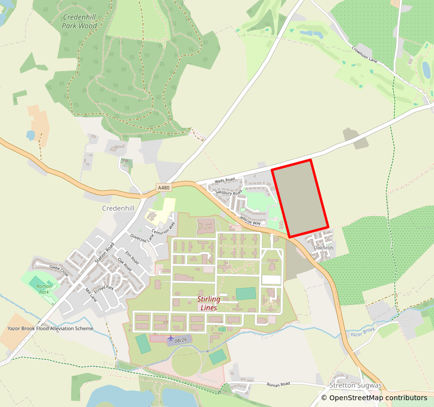
The applicant did not submit a Heritage Impact Assessment with their application. The Council’s own Archaeological Advisor has already said the application is inadequate for this reason. In his consultation response (DOCX), Julian Cotton wrote:
“Further information urgently required”
…it must be strongly emphasised that this is the second largest such hillfort in the UK, with an extensive ‘setting’ that may be at risk here.
Despite what was said at pre-application stage, no heritage impact assessment has now been provided, so the application is currently deficient, and does not accord with policy.
He also noted that “the site’s hinterland is rich in Iron Age and Roman remains” and “the site has archaeological potential.”
The policy this breaches
Policy HE5(1) of the August 2026 National Planning Policy Framework1 says that development proposals affecting heritage assets “should be accompanied by an assessment of the significance of the assets affected (including any contribution made by their setting) and of the potential effect of the proposal on their significance”, with “appropriate expertise employed where necessary”.
Annex C of the Framework lists that “Heritage impact assessment” as a formal information requirement for applications of this kind. And where archaeology is involved, HE5(5) requires “an appropriate desk-based assessment… and, where necessary, a field evaluation.”
Policy HE6(1) requires that “substantial weight should be given to the asset’s conservation (and the more important the asset, the greater the weight should be)” — and HE6(6) treats scheduled monuments as assets “of the highest significance”. HE6(3) adds that “Any harm to a designated heritage asset will be a matter of considerable importance and weight.”
None of that has been done here. And because the assessment required by HE5 is missing, the Council has no way to apply HE6 at all.
Herefordshire Local Plan policy LD42 says development proposals should:
Protect, conserve, and where possible enhance heritage assets and their settings in a manner appropriate to their significance…
Herefordshire Local Plan policy SS63 requires proposals to be based upon “sufficient information to determine the effect” on, among other things, “historic environment and heritage assets, especially Scheduled Monuments.” It adds that:
Development proposals should conserve and enhance those environmental assets that contribute towards the county’s distinctiveness, in particular its settlement pattern, landscape, biodiversity and heritage assets and especially those with specific environmental designations.
The management plans and conservation objectives of the county’s international and nationally important features and areas will be material to the determination of future development proposals.
Why this is important
Credenhill Camp is a nationally—if not internationally—important feature. It is therefore a material consideration in planning terms. By law, the proposed development’s impact on the site or setting of the scheduled monument at Credenhill Camp must be factored into the council’s decision.
Credenhill Park and the hill fort are given cursory mentions in the applicant’s Landscape & Visual Assessment (PDF) and Design & Access Statement (PDF), but only from a perspective of landscape and views, and not heritage. Nowhere does the application describe the significance of the scheduled monument, or properly assess the development’s effect on its setting.
The Council cannot weigh harm it has never been shown. The heritage assessments that NPPF policy HE5 and Annex C require has not been provided, so the application is not in a state where it can properly be determined either way.
What would consideration of the monument look like in practice?
The Council’s Core Strategy does not contain any explicit guidelines for heritage development in Credenhill specifically. But, when outlining principles for development in the “Western Urban Expansion” area between the Roman Road, Three Elms Road, and Kings Acre Road, it states:
4.2.71 […] The development will also be required to conserve and where possible enhance other heritage assets. The historic linkages in this area should not be obscured and new development should maximise the potential for vistas that take in the key landmark and historic feature of Credenhill Park Wood.
It could be argued that, if “conserving” and “enhancing” the heritage asset at Credenhill Park Wood is a requirement when dealing with this parcel of “western expansion” further away from the historic Credenhill monument, then surely the requirement should also apply to proposals for development much closer to the monument.
Highways and traffic
Since the planning application includes access as a matter for decision, the safety and suitability of the A480 junction is fully in play at this stage and can’t be pushed to a later “reserved matters” stage.
We all know the reality: the A480 regularly queues in the mornings (around 8–9am) because of the security arrangements at the Stirling Lines army garrison entrance, which sits almost opposite the proposed site access. The filter lanes to the camp are short, so once they fill, the queue backs up along the A480 – right past where the new junction would go.
Yet the applicant’s Transport Assessment never modelled that junction. The three junctions it assessed were:
- “Proposed Site Access / A480” (the new junction being proposed)
- “Station Road / A480 crossroad” (the junction into Credenhill village, half a mile away)
- “A480 / A4103 roundabout” (the Stretton Sugwas roundabout, three quarters of a mile away)
And while queue surveys were done, they were done elsewhere:4
manual classified turning counts and queue length surveys were undertaken on the Roman Road/ A480 (N)/ A480 (S) roundabout, and A480/ Station Road junction.
The Stirling Lines camp entrance (the actual cause of the morning jam) was not surveyed and not modelled. So when the applicant concludes that “the relevant junctions operate within capacity,” that conclusion is built on a model that leaves out the most important local traffic feature. The development is forecast to add 134 vehicle trips in the morning peak (of which 97 are cars leaving the site onto the A480).
The policy this breaches
This point isn’t about a breached policy (yet) – it’s about a lack of documentation. The applicant has not demonstrated that the access is safe and suitable, because their evidence excludes the queue that everyone who lives here experiences daily.
The August 2026 National Planning Policy Framework sets out what should have been assessed. Policy TR6(3) requires that, in judging whether impacts are severe, “reasonable future scenarios should be considered, taking into account impacts at relevant times of the day, potential cumulative impacts, multimodal trip generation”. Policy TR6(4) then states:
“Development proposals should be refused if they would have a severe adverse impact on the transport network (in terms of capacity and congestion, including cumulative impacts), or an unacceptable impact on highway safety…”
Note the wording: “should be refused”. Under the new Framework this is one of the specific national policies that policy S5 points to as a reason why the benefits of a development can be substantially outweighed. Annex C also lists a “transport statement or transport assessment (depending on the extent and significance of the transport issues involved)” as a formal information requirement under TR6.
It may be that the combination of the new development and the existing Stirling Lines queues don’t ultimately amount to a “severe adverse impact” or an “unacceptable impact on highway safety”. That is indeed a high bar. But we (and the Council) can’t know, because the morning peak at the garrison entrance is exactly the “relevant time of the day” and the “cumulative impact” that TR6(3) requires to be assessed, and it was never surveyed or modelled.
Why this is important
Since:
- the applicant has requested that access be decided now (and not left as a reserved matter);
- and they haven’t provided the documentation we’d argue is necessary for the Council to come to a decision on the proposed access;
- and policy DM1(1) of the August 2026 NPPF requires major development proposals to be accompanied by the information set out in Annex C…
The only solution is that the application must be withdrawn and resubmitted with the relevant surveys and modelling included.
Local services and the “sustainable location” claim
The applicant leans heavily on this being a “sustainable location.” But Credenhill has a convenience store, a chip shop, a small primary school, and not much else.
The applicant’s own Transport Assessment records the main bus service (71/71B) as roughly hourly Monday–Saturday with “No Service” on Sundays.
For 250 new households, most everyday needs (GP, secondary school, larger shops, most jobs) will mean driving into Hereford. That’s the opposite of reducing the need to travel.
Example: local schools
Department for Education data estimates 0.25 primary school pupils and 0.13 secondary school pupils per home in England. Using these estimates, a 250-home development such as the one proposed would introduce ~62 primary school children and ~32 secondary school children into the local school population.
There are three primary schools in the area:
| School | Total pupils, Spring 2025 | 2025/26 PAN5 | 2025/26 offers made |
|---|---|---|---|
| St Mary’s, Credenhill | 140 | 30 | 25 |
| Stretton Sugwas C of E Academy | 177 | 30 | 31 |
| Burghill Community Academy | 92 | 15 | 12 |
An influx of ~62 primary school pupils would overwhelm St Mary’s, Credenhill, which is only allowed to admit 30 new pupils per year, and only had 5 free spaces in 2025/26. Even if we include the other nearby primary schools, this one development would account for almost all of their allowed admissions for the year. Stretton Sugwas Academy was already oversubscribed in 2025/26.
Example: local healthcare
Credenhill once had its own branch GP surgery in the parade of shops off Station Road. But, even before the pandemic, it had shrunk to a handful of half-day sessions a week, and by the end of 2023 Hereford Medical Group was consulting on closing it, on the grounds that the premises were “a safety risk” and “not fit for purpose”. The branch closed in 2024, and the building was marketed for sale in 2025 as premises “suitable for alternative uses”. The nearest operational GP practice is now in Hereford, a ten-minute drive away.
Tellingly, the applicant’s Transport Assessment (dated November 2025) still lists “the health centre… adjacent to the shops” among the local facilities that supposedly make this a “sustainable location” – long after that surgery had closed.
It all makes you wonder – have the people involved in this application ever even visited Credenhill?
The policy this engages
Herefordshire Council’s Adopted 2011–2031 Core Strategy identifies Credenhill as one of 119 “rural areas […] which will be the main focus of proportionate housing development”:
4.8.15 One hundred and nineteen settlements have been identified across the county to be the main focus of proportionate housing development in the rural areas. These are listed in Figure 4.14. Within these settlements carefully considered development which is proportionate to the size of the community and its needs will be permitted.
Herefordshire Local Plan policy SS2 states that:
In the rural areas new housing development will be acceptable where it helps to meet housing needs and requirements, supports the rural economy and local services and facilities and is responsive to the needs of its community.
Herefordshire Local Plan policy SC1 states that:
New development that creates a need for additional social and community facilities that cannot be met through existing social facilities – will be expected to meet the additional requirements through new, or extension of existing, provision or by developer contributions which meet the relevant tests of paragraph 204 of the NPPF.
Can the developer just pay to make this problem go away?
UK planning law includes a mechanism for planning authorities and developers to mitigate the impact new developments might have on local services: Section 106 agreements. But, despite what developers might like to believe, these are not a silver bullet.
Section 106 agreements (named after section 106 of the Town and Country Planning Act 1990) are legal contracts between developers and local planning authorities that ensure developers contribute to local infrastructure and mitigate the impacts of their developments. “Contributions” can include agreeing to a certain proportion of affordable housing, creating on-site infrastructure like roads, drains, and play areas, and/or simply making financial contributions to planned local services.
The applicant’s Design & Access Statement (PDF) already includes a handful such contributions: 35% affordable housing (note: the bare minimum), some green infrastructure, drainage, and a 10% biodiversity increase (again, the bare minimum).
What it doesn’t include is any healthcare or education contribution at all.
The Design & Access Statement (PDF) admits that, in the informal consultation run in early 2026, “GPs, dentists and healthcare” was raised as a concern 60 times and “Schools, nurseries and childcare” 94 times, and then simply asserts these were “addressed through the technical evidence and design framework” — while providing no capacity assessment and no contribution for either.
However even if this oversight were to be amended, the developer cannot simply wave a Section 106 cheque book and make this problem go away. Money only helps where capacity can be physically created. Even with increased funding, if the existing local services can’t physically grow to serve the increased demand, then development is not sustainable.
Ask yourself: Could St Mary’s Primary School expand to accommodate 45% more children, on its current site?
And if, instead, the Section 106 money must be spent on services further away from the village – perhaps piecemeal capacity increases at all three local primary schools, and a new surgery that serves a handful of the local villages – how do residents reach these services? Spending Section 106 money to increase car journeys out of the local community is the opposite of “sustainable” development. So what‘s the solution?
The application is conspicuously silent on this.
Supporting points
There are a number of additional shortcomings in the application which worry us – and while they don’t individually constitute blockers to approval, taken together they point at a perfunctory application, out of proportion with the local village context, submitted with less than the bare minimum evidence.
The scale is not “proportionate” to the village
Credenhill had 782 households at the 2011 Census. A few more were probably built since, plus the 67 at Oakfield View last year. So we can assume there are still fewer than 900 homes in the village. A development of “up to 250” new homes is close to a 30% increase, all in one go. The Local Plan (paragraph 4.8.15) says rural settlements like ours should see:
carefully considered development which is proportionate to the size of the community and its needs
For scale: the entire “Hereford” group of rural villages is expected to take 1,870 homes across the whole 2011–2031 plan period (Local Plan policy RA1). A single 250-home scheme in one village is about 13% of that twenty-year total for the whole area, dropped in one place.
This is not proportionate development.
Flood risk: applicant evidence is out of date and contradicted by the parish’s own flooding record
The applicant’s Flood Risk Assessment & Drainage Strategy (PDF) concludes that flood risk to the site is “negligible/low” and states that Credenhill is not recorded as having experienced significant flooding. But they rely on evidence that is now out of date (a Herefordshire Strategic Flood Risk Assessment of 2019, and Environment Agency flood records that run only to 2014).
The record since then tells a different story:
- Since 2019: properties along the A480 have, in the Parish Council’s own words, been “routinely” flooded – which is why Herefordshire Council funded drainage works on the A480 in January 2026 to reduce that risk. The A480 is the road from which this development takes its access.
- February 2020: the Parish Council’s own flood report (PDF) documents several properties across Credenhill flooded by surface water, water running off the hill and across farmland towards homes, and the Yazor Brook reaching the highest level ever recorded at its gauge – with the Brook so high that surface water could no longer drain into it.
- October 2024: a Herefordshire Council flood alert prompted the Parish Council to commission a fresh storm incident report into flooding across the parish.
- May 2026: at the applicant‘s own pre-application presentation, residents raised concerns about surface-water flooding downstream of the site and existing flooding of a nearby footpath.
This matters for this application specifically. The site is greenfield land on the slope below Credenhill hill. Surface water from the site will discharge towards the Yazor Brook – the same brook that reached record levels and backed up in 2020. The application also relies on the Yazor Brook Flood Alleviation Scheme to reduce downstream risk, yet the parish record shows that scheme’s protection depends on maintenance that has repeatedly not been carried out.
Under Policy SD3 of the adopted Core Strategy, sustainable drainage must be “appropriate to the hydrological setting of the site” and must not increase run-off. That test cannot properly be met on an evidence base that overlooks the flooding the parish has actually experienced in the last decade.
It is imperative, for the safety of the rest of the village, that Herefordshire Council’s Land Drainage team scrutinises the application’s drainage strategy against the parish’s documented flooding history – not against records that stopped in 2014.
Ecology: required survey has not been done
The applicant’s own ecologist6 says bat surveys are needed across three seasons before the effects can be understood:
Night-time bat walkover (NBW) survey work will be required to establish the level of bat activity
…with survey visits in spring, summer and autumn plus static detectors. From a January 2026 report, those simply can’t have been completed before the application went in. The applicant’s data search found 14 bat records nearby, including the rare barbastelle. Bats are a protected species.
Yet the application form answered:
a) Protected and priority species:
No
b) Designated sites, important habitats or other biodiversity features:
No
That’s a formal declaration that contradicts the applicant’s own ecology report. It also contradicts the requirement for “sufficient information” in policy SS6 of Herefordshire’s Local Plan.
And the applicant can’t simply promise to do the bat surveys later, as a condition of approval: Their own ecology report (PDF) quotes government guidance that:
It is essential that the presence or otherwise of protected species, and the extent that they may be affected by the proposed development, is established before the planning permission is granted, otherwise all relevant material considerations may not have been addressed in making the decision. The need to ensure ecological surveys are carried out should therefore only be left to coverage under planning conditions in exceptional circumstances…
No such exceptional circumstances have been argued here.
Overheating hasn’t been assessed
As the UK emerges from its third heatwave of 2026, we note that the National Planning Policy Framework requires planning applications to take full account of all climate impacts, and names overheating explicitly.7 Herefordshire’s Core Strategy Policy SS7 requires new development to use “passive solar design for heating and cooling” and “tree planting for shading”.
Yet the application contains no overheating assessment at all. No Energy or Sustainability Statement has been submitted, and the Design and Access Statement (PDF) addresses energy only in terms of carbon and cost.
This matters most for the houses nearest the A480 junction. The applicant’s Noise Assessment (PDF) concludes that these plots must keep their windows closed to achieve acceptable indoor noise levels. But opening windows is exactly how new homes are expected to shed heat under Building Regulations Part O. Where noise rules this out, the likely alternative is air conditioning – which adds energy and cost, and contradicts the low-carbon claims made elsewhere in the application.
Loss of farmland hasn’t been assessed
The site is arable farmland, but the applicant submitted no Agricultural Land Classification (soil quality) assessment. Loss of good-quality (“best and most versatile”) farmland is a genuine planning consideration, and Herefordshire Local Plan policy SS6 lists “agricultural and food productivity” and “soils” among the things that need “sufficient information.”
Another piece of evidence that hasn’t been provided.
Mineral safeguarding study has not been done
The proposed development overlaps a Mineral Safeguarding Area buffer zone:
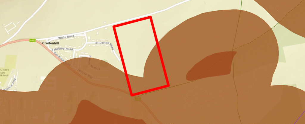
Policy M2 of Herefordshire Council’s Minerals and Waste Local Plan (adopted March 2024) applies “across the totality” of that area, including the buffer. On that basis the plan says an applicant “will be required to submit… a mineral resource assessment,” and the application doesn’t contain one.
So, strictly, this is yet another required assessment that is missing.
Next: How to object →
- August 2026 NPPF. ↩︎
- Herefordshire Council Local Plan Core Strategy 2011–2031. ↩︎
- Herefordshire Council Local Plan Core Strategy 2011–2031. ↩︎
- P262019/O supporting document: Transport Assessment (PDF) ↩︎
- PAN = “Pupil Admissions Number”, the maximum number of new children a school is allowed to admit per year. ↩︎
- P262019/O supporting document: Preliminary Ecological Appraisal with Preliminary Roost Assessment (PDF) ↩︎
- 2026 NPPF policy CC3(1)[9] says development proposals “should take into account the current and potential impacts of climate change over the lifetime of the scheme”, and where relevant should “use design approaches which minimise risks from overheating”. Policy DP3(2)(b) requires development to use “building layouts, building orientation, massing, landscaping and materials which conserve energy and other resources, and which minimise risks from the impacts of climate change including overheating”. ↩︎